
Tags
before and after, ecology, erosion, farm, Fleurieu Coast, one rock dam, planning, reuse, seasons, soil, southwestern Fleurieu, water, waterways, winter

Rain, and a full dam.
By late July this year we’ve already exceeded our entire rainfall for 2015, and for now, the rain shows no signs of abating. This is fantastic news for our revegetation efforts, and our dam is now almost full for the first time in two years. With heavy rains – we managed to top 100mm (4 inches) in a single day – it’s also a chance to test the effectiveness of the erosion control strategies we’ve employed.
With significant erosion in some key areas of the property, we’ve worked to adapt erosion control strategies such as those practised by Bill Zeedyk and Craig Sponholtz (see April’s Waterway Restoration workshop/working bee and our Resources page for more information). In particular, we’ve constructed Zuni bowls, for arresting headcuts, and One Rock Dams, to slow water flow, catch sediment and gradually lift the floor of erosion gullies. After the recent deluge, we toured the works to see how we went. The Zuni bowls have had mixed success: those in relative stable locations have been effective, those in dispersive soils have been unpredictable. The One Rock Dams (ORDs) have been generally successful, if swamped by sediment!
The impact of 100mm of rain in one day is significant: exposed areas lose significant amounts of soil (some areas of gully floor had almost 30cm of freshly deposited sediment), and areas of dispersive soil go berserk, collapsing in all directions. For some of these areas, we’re continually seeking further advice, but for those we can manage, we monitor and tweak over time, and try to “let the water do the work” in healing the landscape.
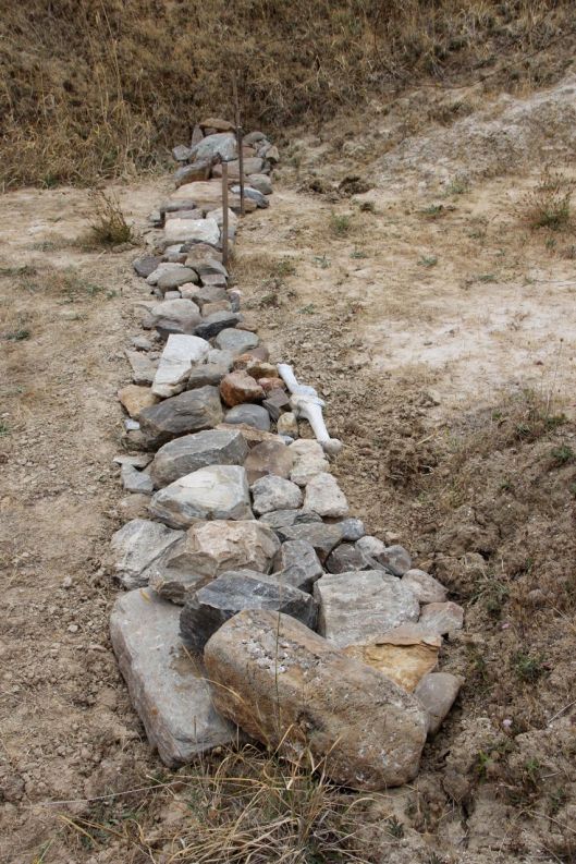
One Rock Dam #1: Dam Creek
Our first One Rock Dam was constructed below a bare, erosive gully wall in January 2015, and after the dry winter of that year it was showing promise at holding moisture and catching sediment. After the 100mm-in-a-day experience of this winter, it’s totally swamped by sediment and ready for it’s second layer of stone to continue to raise the gully floor. On reflection, this dam should have been about three times wider (aiming for about 1.5m) to more effectively hold sediment.
Our first One Rock Dam after construction, January 2015.

Inundated with sediment and ready for its second layer of rock, July 2016.

Our first One Rock Dam, after construction, January 2015. The brush weirs above were intended to support grass growth on the face of the eroded areas, with mixed success.
Inundated with sediment, July 2016.

Sediment galore.
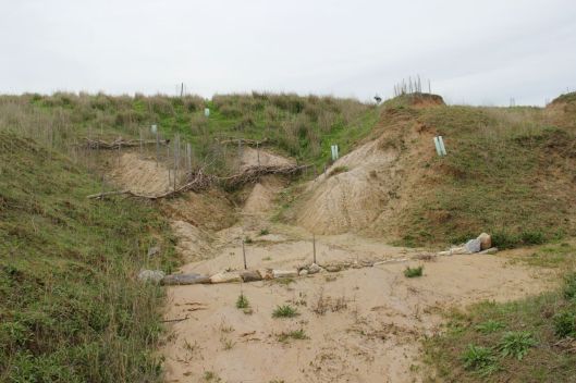
One Rock Dam #2: Kalta Creek boundary
While ideally erosion control and water harvesting efforts should begin at the top of a watershed, in addition to our other strategies, we thought it useful to construct an ORD at the bottom of our watershed in an effort to limit the amount of sediment carried off our property. This ORD was constructed from rubble gathered from nearby historic dumping, and went through a couple of tweaks to increase its effectiveness. Following winter rains, it’s effective at holding sediment.

The gully, pre-ORD.

One rock dam, version 1, summer 2016.

The dam, showing its moisture retention ability with green grass following summer rains. Note the lack of growth in the bare soil of the gully floor.

Version 2, widened to about 1.5m, and armouring adjacent erosive gully faces.
The tweaked dam, from the other bank.

The dam, following winter rains. Plenty of sediment, but most of it has been caught by the rubble and vegetation growing. Clear water is pooling on the downstream side of the dam.
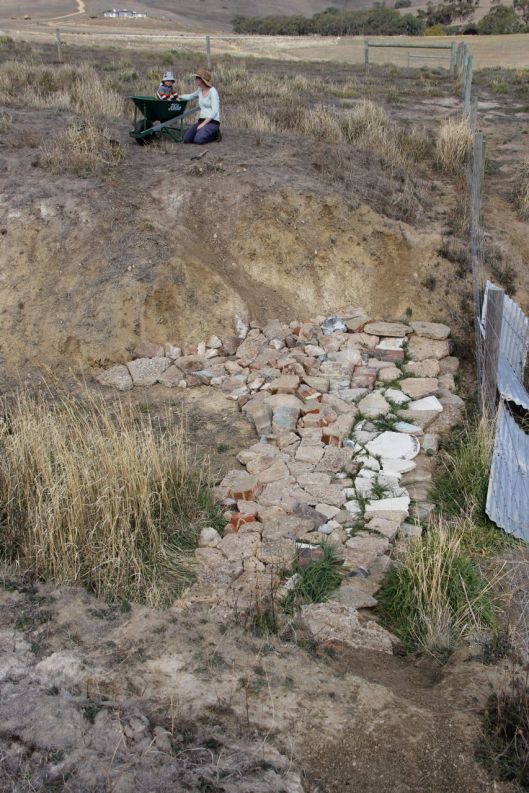
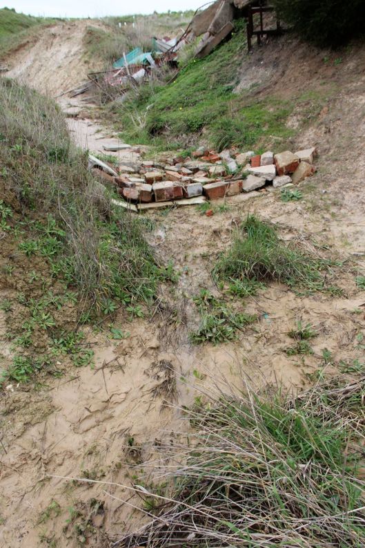
One Rock Dam #3: Kalta Creek, clean-up zone
This dam was constructed by our amazing community of volunteers below the main clean-up area at 2016’s Waterway Restoration workshop/working bee. It utilised dumped construction rubble from nearby, and once again it’s working well holding sediment from upstream and slowly raising the gully floor.

Rubble One Rock Dam, looking downstream, after construction, April 2016.

Rubble One Rock Dam, looking downstream, July 2016. Plenty of sediment on the upstream side. The besser block in the foreground was surrounded by rubble to fill in a potentially erosive hole. It’s now filled with sediment.
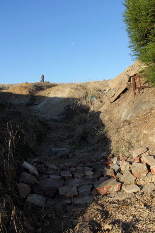
Rubble One Rock Dam, after construction, looking upstream, April 2016.
Rubble One Rock Dam, looking upstream, July 2016. Note the lack of sediment on the downstream edge of the dam, and the flow patterns in the grasses. Note also, that there is still a wealth of junk to be hauled out beyond!

Great to see J & S. Thank you
Thank YOU Anthony, great to have you as part of our amazing WWOOFing team!
Great documentation Joel and Sophie! It’s amazing how dynamic the landscape is – you kind of forget when you see it day to day, but the before/after photos are a great reminder of the constant change. Any more tunnelling happening in the up-slope sections?
Thanks Nat, the slow, constant changes are harder to notice, so photos are a great source of reassurance that something – hopefully positive – is happening. With the deluge there has been some movement with the tunneling, but it’s not always predictable which makes it all the more complex to manage. The Zuni bowl you helped construct mostly held, but collapsed where water flows concentrated, other areas typically moved a metre or two following the big rain. We’re continuing to seek advice on these spots! Look forward to catching up soon!