
Tags
art, ecology, erosion, farm, history, livestock, photography, planning, revegetation, seasons, soil, southwestern Fleurieu, summer, trees, water, waterways, winter
It’s been a dry year on the Fleurieu Peninsula. After the inundation of 2013, 2014’s rainfall came in almost 200mm shy of the year before, and about 100mm short of the average. By February 2015, the dam had receded to a few centimetres of sludge, and the water carter had come to top up the stock water tanks. While there’s no doubt that the Fleurieu Peninsula has had the Mediterranean pattern of dry summers and cool, wet winters for some time, recently I’ve begun to wonder whether this pattern has shifted towards greater aridity as successive land-uses have cleared the landscape.

Curruckalinga, looking over St. Vincent’s Gulf, 1846, George French Angas, depicting a mosaic of woodland and open grassland. From the description: “This view is taken from the rocky hills near Mr Kemmis’s Station, to the northward of Rapid Bay … The undulating appearance of the country here represented, together with the singular manner in which the trees are dotted about in all directions over the landscape … principally ‘casuarinae’ or she-oak, with ‘eucalyptus’.” From the collection of the State Library of South Australia, B15276/33.
At the time of European colonisation, the Fleurieu Peninsula was most likely covered with a mosaic of woodland, forest and grasslands, maintained through Aboriginal burning and land management practices. In his paper on the discovery and settlement of the Fleurieu (1986), Rob Linn draws from the diaries of settlers in his descriptions of the landscape of the South Western Fleurieu. Writing in 1838, William Giles described the landscape around Rapid Bay, as “a most beautiful valley, the soil of great depth covered with most luxuriant herbage … on the sides of these hills we found plenty of keep for sheep, and wherever the grass had been burnt in these places it was looking beautifully verdant … fine land, excellent water, plenty of timber …” This was echoed by John Stephens in 1839, describing the “country from Cape Jervis upwards” as “very picturesque” and “well-timbered” (Linn 1986).

The Gorge, Yankalilla, 1871, depicting vegetation on the coastal cliffs, near where present-day Main South Road crosses the Yankalilla River. From the collection of the State Library of South Australia, B19714/42.
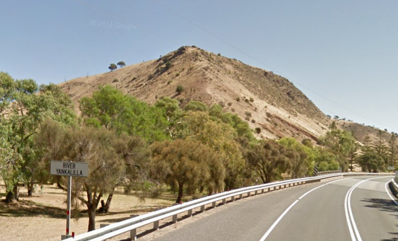
The Gorge, Yankalilla, February 2014, via Google Street View. While the park at the base of the hill is planted with vegetation, the hills above are significantly denuded from their earlier state.
The descriptions of the South Western Fleurieu being relatively well timbered are further evidenced in early landscapes of the region. The paintings of George French Angas, many produced in the 1840s, typically depict the landscape as an open woodland, dominated by eucalypts, peppered with groves of sheoaks, xanthorrea, and acacias. As an example of how the landscape has changed, a 1871 photograph of the Gorge where Main South Road crosses the Yankalilla River, depicts the now-bald coastal cliffs as modestly wooded, primarily with sheoaks, a profusion of yakkas lining the roadside, with eucalypts in the river valleys. The previously wooded state of the landscape is depicted again in the 1880s photographs of the hills opposite the original Anacotilla cottages, showing woodland of greater spread and density than the present day.
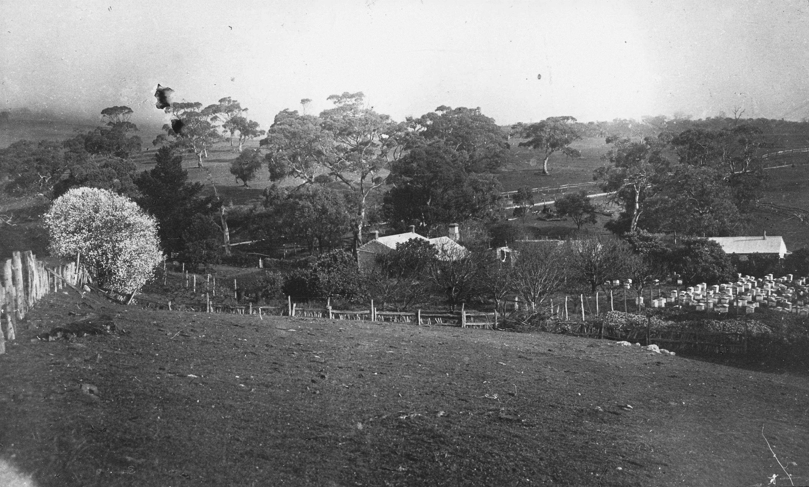
Anacotilla, Second Valley, home of A.C. Kelly in the 1880s. This dwelling is the present day ‘workers cottage’ on Main South Road. Note the mist and woodland over the hills opposite. Image courtesy of the Yankalilla & District Historical Society.
Just beyond the back boundary of our farm lies Yarnauwingga, or “the place of bald (hills) water”, a traditional meeting place for the Kaurna. That the hills surrounding this site are now thick with trees, planted in the early stages of the Wirrina resort project in the 1970s, suggests that any ‘baldness’ was most likely a function of land management practices rather than ecological limits.
With colonial agriculture established on the Fleurieu Peninsula by 1838, the existing vegetation underwent several waves of clearing, firstly by logging for timber and to open up land for cropping and grazing. This was followed by the cutting of golden wattles for use of their bark for tanning, then the harvesting of yakka resin (Blum 1985). Although forestry is long established in the highlands above Second Valley, the region is still dominated by grazing and dairying as its primary land uses (Liddicoat & Hermann 2002).
Natural Sequence Farming founder Peter Andrews asserts, “Plants are the be-all and end-all of the landscape … plants run the system” (2006, p. 163). As a consequence, the colonial process of clearing the landscape unleashed a cascade of unforeseen consequences. Without a tree canopy protecting the soil, and without tree roots managing water below the soil surface, the open grassland became vulnerable to erosion. As watershed restoration expert Craig Sponholtz articulates, when grazing diminishes vegetation cover, rainfall begins to flow over the ground surface, forming rills and channels. As this surface water channelises, it increases in velocity and erosive potential. Water that was distributed over a broad surface area becomes concentrated into a deepening gully. Where the water was previously harvested in the soil and cycled through ecological processes, it now races along gullies that drain it from the landscape, leaving the soil desiccated (Footer 2014). In his analysis of the dehydration of Australian floodplain landscapes, Cam Wilson also highlights how colonial land management practices often disrupted the relationship between waterways and groundwater (2011). The consequent erosion from deforestation and unchecked grazing not only drained surface water, but also interrupted groundwater flow, lowering it to the depth of the newly formed channels and beyond the reach of existing vegetation. In such circumstances, as the land dries out, vegetation undergoes succession as the existing wetland species are replaced by more drought-tolerant upland species (Footer 2014).
Beyond erosion, there may also be other, subtler patterns at work in the drying of the Fleurieu post-colonisation. Writing in Bioscience, Douglas Sheil and Daniel Murdiyarso articulate an emerging hypothesis that attempts to unravel the complex relationships between rainfall and forests, asserting that there may be a sound foundation to the traditional wisdom that “forests attract rain” (2009). Sheil and Murdiyarso describe forests as an “atmospheric moisture pump” that, when continuing unbroken from the coast, serve to draw moisture into dry continental interiors. As a converse description, the clearing of coastal forests could potentially see the “switching” of continental interiors to desert as the “biotic pump” of forest ecosystems is destroyed. As a continuation of this hypothesis, they ask whether forests themselves are an example of “emergent, self-stabilising behaviour”, describing how “trees and forests have evolved numerous times in Earth’s history, suggesting a repeated trend to generate rich, self-watering terrestrial habitats” (Sheil & Murdiyarso 2009). In the context of the Fleurieu Peninsula, this suggests that under increased tree cover, there may have also been an increased rainfall, as evidence of the “biotic pump”. Intriguingly, this appears to be supported by Bureau of Meteorology rainfall records. With records beginning down the road from our farm at Poolamacca in 1883, there appears to be a clear downward trend in annual rainfall to the present day. The opening decades of record-keeping show reasonably regular annual rainfall above 800mm, with the final recorded year above 800mm almost 100 years ago in 1917. While there are any number of factors that influence rainfall, it’s also intriguing to note the presence of ancient manna gums on the hills that overlook our farm. With our rainfall now hovering around 550mm a year, perhaps these gums are a lingering memory of a wetter time.
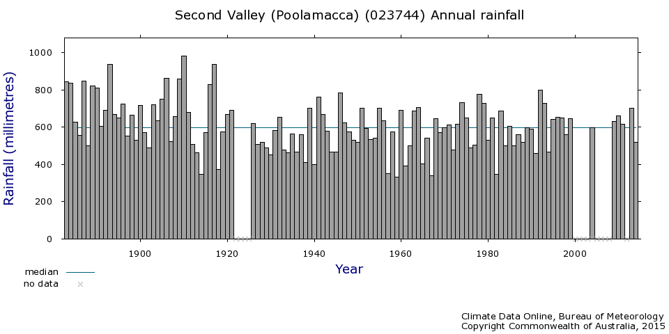
Rainfall, as recorded at the Poolamacca station near Second Valley, seems to indicate a decline since the 1880s, with the last recorded rainfall above 800mm in 1917.
Some observers are increasingly aware of the role of local, ‘short-circuited’ or ‘closed’ water cycles, and their loss through land clearing. In contrast to the operatic scale of the long hydrologic cycle that sees water transition from land to oceans to clouds and back again, in areas with “well-established vegetation cover and … soil organic matter”, short water cycles cycle water and nutrients in highly localised environments and over short time spans (Ripl & Eiseltova 2009). “Such water, in the form of dew, is extremely important to maintain optimum micro- and meso-climatic conditions.” Furthermore, the disruption and disappearance of short water cycles through deforestation also “greatly hinders vegetation growth”, and tends to increase the intensity of temperature fluctuations for a site between both day and night and from season to season (Ripl & Eiseltova 2009).

Shrouded in mist: was this once a regular source of moisture for the woodlands of the South Western Fleurieu?
A farmer at Parawa once described to us how he recalled the winters of his childhood as being defined by constant mist and drizzle, a contrast from the present pattern of discrete dry period and rain events. While we have no evidence that a similar pattern was once present around Second Valley, it is interesting that one of the 1880s photos of the Anacotilla property depicts the hills to the south of our farm shrouded in low cloud (see above). If such a climatic phenomenon occurred regularly, the interception of mist by vegetation could have served as another mechanism for hydrating the landscape. Writing of vegetation on the high points of the Mount Lofty Ranges, Peter Schwerdtfeger asserts that during drier spring and summer periods, the landscape “may frequently benefit” from “the capture of cloud droplets by tall trees on occasions when normal thermodynamic processes are inadequate to cause precipitation. A wide range of indigenous and exotic plants owe their survival through the summer to this temporal augmentation of effective rainfall” (1976, p. 78). This pattern is also noted by Osborn and Adamson, who assert that “the persistence of cloud at the higher altitudes [of the Mount Lofty Ranges] must be taken into account … an appreciable amount of water which will not affect the annual rainfall must condense upon the vegetation. Precipitation at Mount Lofty is occasionally in the form of snow…” (1924, p. 93).
In imagining our landscape not-so-long-ago, we are offered clues as to its future potential. If even a fraction of our guesswork is accurate, then the wooded landscape of our colonial ancestors was most likely moister and more effective in harvesting and managing water. Bringing back trees carries a suite of benefits. At their most optimistic, writers like Sheil and Murdiyarso assert that the reforestation of the world’s coastal belts has the potential to green the world’s deserts by reactivating the “biotic pump” of forests and rainfall in dry continental interiors. While such thought experiments help to expand the context for whatever we do on our property, building our understanding of the patterns of water in the landscape also has a number of small-scale implications. As Brad Lancaster highlights, water in erosion gullies is lost to the landscape, so it’s important to harvest water high in the landscape, and one of the most efficient ways to manage water is in healthy soil and vegetation. Overtime, through watershed restoration methods we may be able to raise the gully floors and restore them to functioning wetlands, but for now: we plant trees, and wait to see what happens next.
We welcome your comments, suggestions and own ideas about the ecological history of the Fleurieu, and options for landscape restoration. For more information on erosion management and watershed restoration, check out our Resources page.
References
Adamson, R. S. and Osborne, T. G. B., 1924, The ecology of the eucalyptus forest of the Mount Lofty Ranges, (Trans. R. Soc. S. Aust. 48, 87-144)
Andrews, P 2006, Back from the Brink: How Australia’s landscape can be saved, ABC Books, Sydney
Blum, R 1985, The Second Valley: A history of Second Valley, South Australia, Ron Blum, Oaklands Park
Footer, D 2014, Water – simple, yet complex with watershed artisan Craig Sponholtz, podcast, Permaculture Voices, San Diego <http://www.permaculturevoices.com/46>
Liddicoat, C & Hermann, T 2002, Southern Fleurieu Peninsula Salinity Management Plan, Rural Solutions SA, Adelaide
Lancaster, B 2006, Rainwater Harvesting for Drylands and Beyond, Rainsource Press, Tucson
Linn, R 1986, ‘The discovery and settlement of the Fleurieu Peninsula and the Angas/Bremer Region, 1802-1861’, Journal of the Historical Society of South Australia, no. 14, pp. 51-66
Ripl, W & Eiseltova, M 2009, ‘Sustainable land management by restoration of short water cycles and prevention of irreversible matter losses from topsoils’, Plant Soil Environ., vol. 55, no. 9, pp. 404-410
Schwerdtfeger, P 1976, ‘Climate’, Natural History of the Adelaide Region, C R Twidale, M J Tyler & B P Webb (eds), Royal Society of South Australia, Inc., Adelaide
Sheil, D & Murdiyarso, D 2009, ‘How forests attract rain: an examination of a new hypothesis’, Bioscience, vol. 59, no. 4
Wilson, C 2011, ‘The dehydration and rehydration of the Australian landscape’, Earth Integral, accessed 5 March 2014, <http://earthintegral.com/2011/11/10/the-dehydration-and-rehydration-of-the-australian-landscape/>

Great article Joel! Imagine the benefits of having a gentle mist watering everything over long periods compared with short, erosive downpours! Also check out a paper by Pringle and Tinley on landscape dehydration-http://onlinelibrary.wiley.com/doi/10.1046/j.1442-8903.2003.00154.x/abstract it’s about a more arid climate but has some great insights and pictures as well
Hey Nat, thanks so much for your comments. How we dream of the gentle mist! For now though, we’ll just try and reinstate a woodland canopy to help soften the impact of the rain and make use of it in the soil. Thanks for the link too, most interesting!