
Tags
design, ecology, erosion, farm, fencing, permaculture, planning, soil, southwestern Fleurieu, water
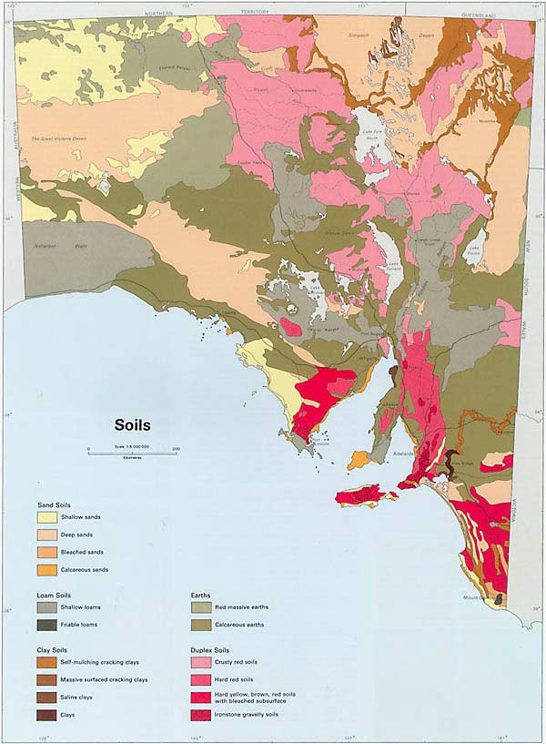
Soils of South Australia, divided into 16 subgroups, from the 1986 Atlas of South Australia.
Recently we’ve been thinking a lot about soil. After all, it is the International Year of Soils, and really, without dirt, there’s not much else. Understanding how our soils work and how to restore them is an essential part of our regeneration project and their structure and composition help define the boundaries of what’s possible on our patch of ground. As Adamson and Osborn asserted in their pioneering 1924 study of the ecology of the eucalypt forests of the Mount Lofty Ranges, climate and soils are the primary factors in determining ecological variation in the region, so even where the scrub has long been cleared, soils can also offer a memory of past ecosystems.
However, it’s taken us a while to unravel meaningful information about soils. There’s a whole new vocabulary, and when you don’t yet know your Kandosols from your Kurosols the whole experience can be a bit mystifying. To make things even more complex, there are oodles of different technical terms for describing any particular soil type, depending on era or classification systems. So we thought we’d share some resources that we’ve come across that may be of use in working out what you’re sitting on.
As always, we started with observation. We’ve been digging holes and looking mournfully at the soil profile in our erosion gullies for almost three years now, we have a reasonable familiarity with its colour and texture across the block. In our heads we have a map of the main soil types we’ve observed, based on their colour variations and differences in if and how they harden and crack in summer. Our paddock divisions broadly reflect these differences too. We always knew that clay was a big part of their composition, and when we got soil tests done, all soils across the block came back described as “clay loam”. Soil tests are excellent for determining the chemical and nutrient composition of a soil, but may not give much insight into how they ‘work’ in the landscape.
For a broad overview, we went first to the CSIRO’s Australian Soil Resource Information System’s Soil Mapp. This app overlays key soil types onto a satellite map, allowing users to select an area of interest. It then ranks likely soil types for that particular area, and also provides a summary of relevant local sample sites. The ASRIS Soil Mapp uses soil order terminology from the Australian Soil Classification system, so according to this tool, our most likely soil types are “Brown Sodosol” and “Grey Vertosol”, with an outside chance of some “Brown Kurosol”.
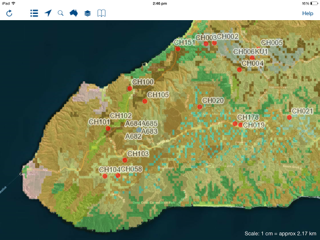
Map image from CSIRO’s Soil Mapp, showing soil types of the southwestern Fleurieu Peninsula, together with sample sites indicated by red dots.

Summary information from CSIRO’s Soil Mapp, ranking most likely soil types for indicated region.
For a more refined view, we then used the South Australian Government’s NatureMaps online Geographic Information System tool. Within this, you can opt to apply “Land Systems” and “Land Types” layers, based on the State Land and Soil Information Framework data, managed by the SA Department of Environment, Water and Natural Resources. If you also apply a “Cadastral Information” layer, you can zoom your heart out and get soil information for individual plots of land.

Land Type map, generated in NatureMaps, with cadastral boundaries in pink, showing the key soil types from Cape Jervis to Yankalilla and south to Parawa.
From this map, we get a more descriptive suggestion for our primary soil type: the landscape is composed of “rises and plains with mainly loamy texture contrast or gradational soil”, “formed on unconsolidated sediments/deeply weathered rock.”
This map information – particularly the shape of your soil zone – is then useful when cross-referenced to Hall, Maschmedt and Billing’s The Soils of Southern South Australia (also available online in two parts: Part 1, and Part 2). This book contains comprehensive descriptions of how soils function, as well as detailed summaries of the characteristics of each identified soil type for South Australia. It’s all supported by helpful table aligning the different soil terminology to their own classification system too! Accordingly, our block is part of region that is composed of about 10-30% brown or grey cracking clay (soil E3 – Australian Soil Classification Grey Vertosol), and greater than 30% sandy loam over poorly structured brown or dark clay (soil F2 – here it differs from ASRIS, identifying this soil as Brown Chromosol). The detailed information provided provides an overview of inherent fertility, but also information about how the soil behaves in the landscape: its ability to hold water, or its dispersive, waterlogging or erosive potential.
There are plenty of other resources floating around (the Royal Society’s 1976 Natural History of the Adelaide Region, for example, or organisations such as Soils for Life provide links and organisations connected with restoring soils), and even some variation in information between those described above. Through our own observations, we’ll continue to verify the research we come across, drawing from those resources that appear to most accurately reflect the unique limitations and potential of our patch of ground, and using their insights to plan effectively for the future. (Eventually, we might even add a “Soils” section to our One-Page Place Assessment!)

Pingback: The ground beneath your feet: resources for exploring soil | Trees, Bees & Cheese | WORLD ORGANIC NEWS